This feature makes it possible to easily create a large sets of geozones or make changes to a
set of geozones at once.
Do as following:
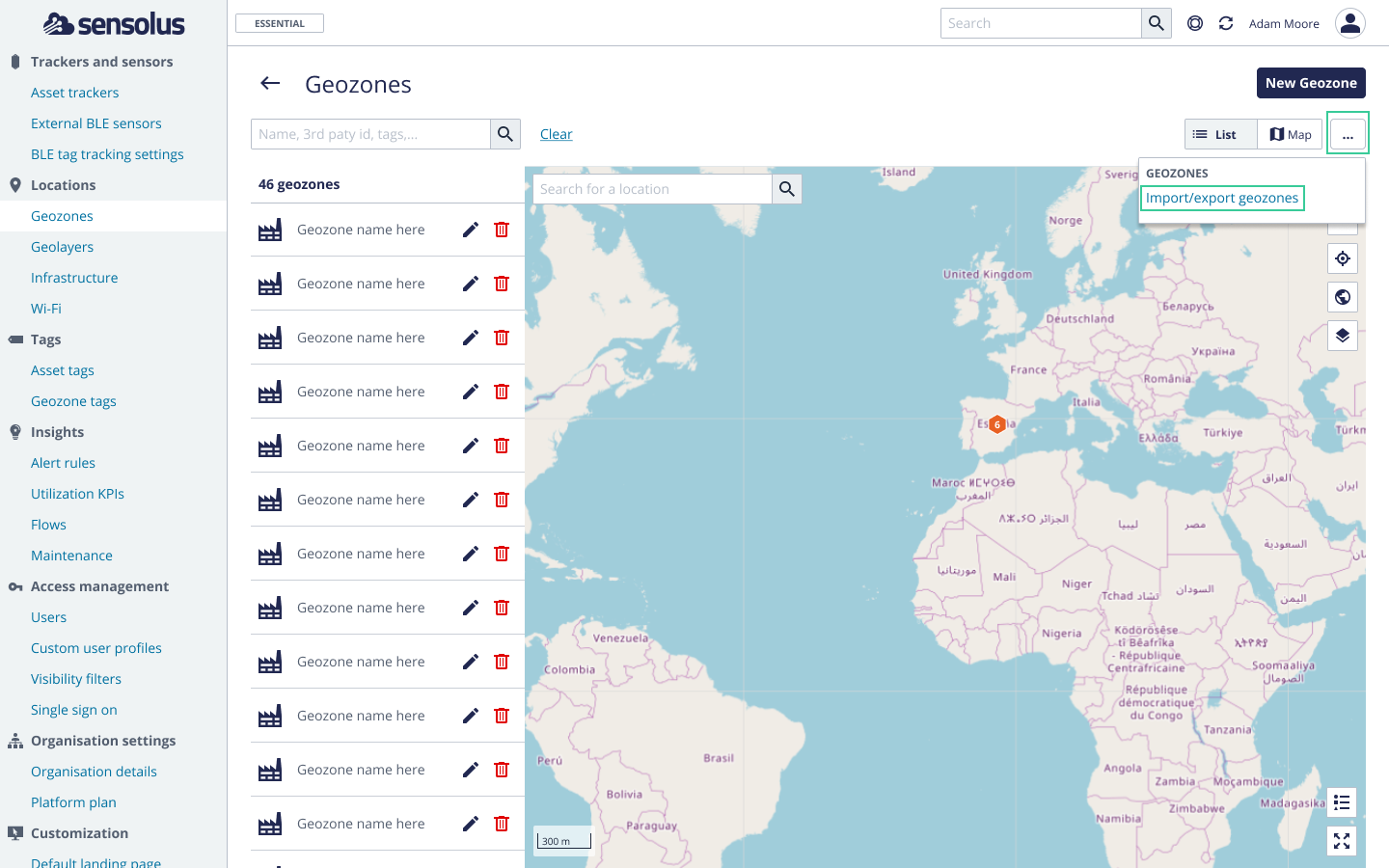
Go to Admin →
Location → Geozones
Click on the overlay menu
and select Import/export geozones. Figure 1. Import or export multiple geozonesA new window will open:
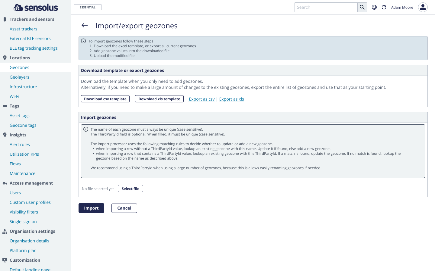
Download the template if you want to import geozones, select the Export as
csv or Export as xls link if you want to export
geozones.
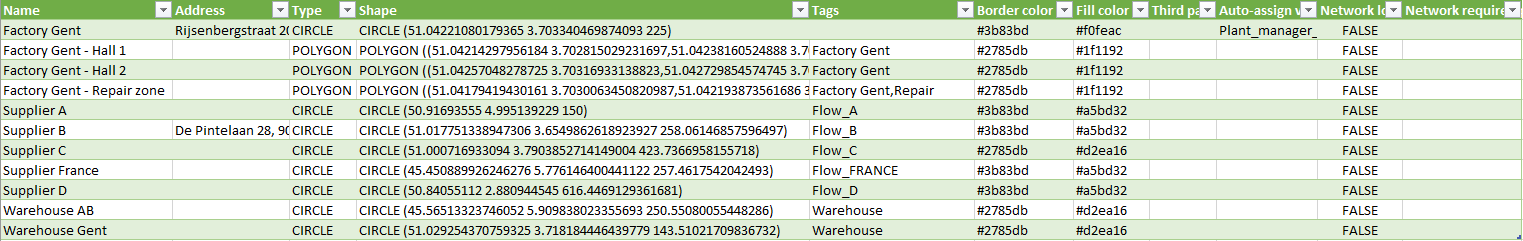
The downloaded template contains following columns:
Table 1. Geozones import template
Name
Mandatory field. Give a unique name to your geozones.
Address
Optional field.
Type
Mandatory field. Choose between CIRCLE or POLYGON
Shape
Mandatory field.Two shapes are supported CIRCLE and POLYGON. Example
descriptions:
CIRCLE (LAT LONG RADIUS), for example: CIRCLE (51.052205 3.723651
2000)
POLYGON ((LAT LONG, LAT LONG, LAT LONG, LAT LONG, ...), for example
POLYGON ((51.042 3.703,51.042 3.703,51.042 3.703))
Note: If you don't fill in this field, but you filled in the
Address field (ideally you use the format: Street name house number, city,
country) we try to resolve a geozone out of the given address. If this is
successful, the geozone will be a circle with a radius of 1 kilometer.
Tags
Add geozones tags to your geozone (optional). For example: Factory Gent, Repair
shop, Belgium
Border color
Give the border color of your geozone. Use Hex colors. For example #2785db
(optional)
Fill color
Give the fill color of your geozone. Use Hex colors. For example #d2ea16
(optional)
Add automatic assignment of visibility filters on assets, depending on the
presence in the geozone of the asset. For example: plant_management
(optional)
By default set to FALSE. If changed to TRUE the network location information
will be used to determine presence inside our outside the geozone.
(optional)
By default set to 15000 meters. If you want network location to be shown only
with higher precision, change this number (optional)
An example template that is filled in looks like this:Figure 2. Example geozone import
Filling in the ThirdPartyId field is optional. But when filled, it must be unique (case
sensitive). The import processor uses the following matching rules to decide whether to
update or add a new geozone.
Note: When a new geozone is uploaded that contains a ThirdPartyID that is
identical to an existing geozone with the sane ThirdPartyID, the already existing geozone will
be updated.
Note: When a new geozone is uploaded that contains a ThirdPartyID that is
different of the existing geozones, lookup is based on the name of the geozone (see next
note).
Note: When a new geozones (without ThirdPartyID) is uploaded with the
same name as an existing geozone on the platform, the already existing geozone will be
updated.
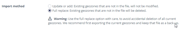
Once the file is created, you can upload the file (and so the geozones) to the platform.
Select the file from your local drive and choose carefully between updating or added geozones
to the geozones already available on the platform or fully replacing the existing geozones by
the ones in the file (be carefully when choosing this option!):Figure 3. Import methods for geozones
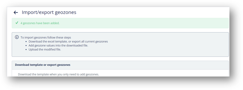
If successfully uploaded, a confirmation will appear on the top of the page.
Figure 4. Successful upload confirmation
You can also check the list to see if the new geozones appeared.
Import geozones by address
Sometimes you don't have coordinates of the locations you want to create a geozones.
Therefore, it is also possible to upload the xls or csv file with only the address and not
the full coordinates of the geozones. The platform will then create a geozone with radius 1
kilometer around the address you mentioned in the Excel.
Note: Always select CIRCLE as Type in the uploaded file.
Note: Optimally use the format "Streetname number, city, country" in
the Address field.
Note: This only works for locations of which you have the Streetname
+ number, city and country information. This method doesn't work to create a geozone of
for example a whole city of country.
 Admin →
Location → Geozones
Admin →
Location → Geozones overlay menu
and select Import/export geozones.
overlay menu
and select Import/export geozones.