Localization techniques
Learn about different localization technologies that are used by Sensolus trackers.
Sensolus trackers can often make use of multiple localization techniques, because each technique has particular advantages and limitations.
The following localization technologies are supported:
|
|
|
|
|||
|---|---|---|---|---|---|
| GPS/GNSS | Network location | Wi-Fi scanning | Bluetooth geobeacons | Bluetooth Quuppa | |
| Ideal environment | Outdoor Everywhere |
Indoor-outdoor Everywhere |
Indoor-outdoor Uncontrolled |
Indoor Controlled |
Indoor Controlled |
| Positioning accuracy range | ~5m up to 50m (configurable) | ~1km up to 10kms | ~50m up to 700m | ~20m up to 50m | ~1m up to 3m |
| Optimal achieved accuracy | Exact location | City-level precision | Building-level precision | Room-level precision | Exact location |
| Battery usage | Medium | Low | Low | Very low | Low |
| Infrastructure | No | No | No Leverage existing IT infrastructure |
Yes No wiring, self-install |
Yes Wiring, certified installer |
| Cost | $ | $ | $$ | $ | $$$$$ |
Localization technologies can differ on multiple aspects:
- Ideal environment: is the technology suited for indoor, outdoor or mixed environments and should the user control the environment to install some infrastructure or not.
- Energy consumption: the amount of energy consumed, which impacts the total lifetime of a battery powered tracker.
- Positioning accuracy range: how accurate the position is depends on a multitude of factors, but here we show the possible accuracy range.
- Optimal achieved accuracy:on which level or how precise can you track your asset?
- Battery usage:how much battery power does the tracker use to get a location using this technology?
- Infrastructure: Is there extra infrastructure needed to use this location technoloy? Is wiring needed and can users do it themselves or do they need a certified installer?
- Cost: rough cost comparison of the differences in cost per location technology.
Combining different localization technologies
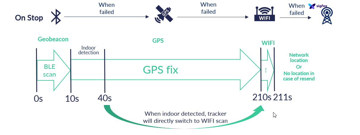
The order and priority of a location capture is implemented as a workflow with configurable actions and conditions.
The figure below shows an example of a location capture workflow:

In this example, the tracker will try to determine its location in the following order: BLE, GPS, Wi-Fi and network localization. A subsequent localization will only be attempted if the previous localization was unsuccessful. This configuration example is very suitable for a use case where BLE geobeacons are be installed and where the asset is also often outside and the highest precision GPS localization is desired. The Wi-Fi gives a good fallback for indoor locations. As a last resort, network location is used.
In the following example, the indoor detection setting has been enabled for the GPS localization step. When insufficient GPS satellites are detected, the tracker will assume it is indoors and immediately fall back to Wi-Fi localization instead of waiting for a GPS fix.

Successful, degraded and failed localization capture
| Successful capture | Degraded capture | Failed capture | |
|---|---|---|---|
| Technology | GPS/BLE/Wi-Fi | GPS | GPS/BLE/Wi-Fi |
| Requirement | GPS: within accuracy requirement BLE: minimum one geobeacon scanned Wi-Fi: minimum two Wi-Fi mac address scanned |
Accuracy between accuracy requirement and accuracy acceptance. | GPS: accuracy worse than acceptance. BLE: no geobeacon found. Wi-Fi: fewer than two Wi-Fi mac addresses found. |
| Result | Message sent including location & predicted accuracy | Message sent including location & (lower) accuracy | Message sent with fallback to network location (low accuracy). Note: if message is resent later with data integrity, no location is available. |
Network location fall back
Network localization is in most cases used as fall back mechanism if no other localization technology was able to provide location information to the tracker. If no other technologies provide a location, the tracker checks the network localization of the tracker. This location information is never precise as it uses triangulation of netwerk antenna's to define the location of the tracker. If the last precise location (provided by GPS, Wi-Fi or geobeacon) is more then 200 km away of the network location of the tracker, the network location will be taken as the new location.
Localization technologies for indoor tracking of trackers
| Wi-Fi scanning | Bluetooth geobeacons | Bluetooth Quuppa infrastructure | |
|---|---|---|---|
| Positioning accuracy range | ~50m up to 700m | ~20m up to 50m | ~1m up to 3m |
| Accuracy level | Building-level precision or distant rooms | Room-level precision or zones >20m apart | Exact high-precision location |
| Infrastructure | No Leverage existing IT infrastructure |
Yes No wiring, self-install |
Yes Wiring, certified installer needed |
| RT technology | Wi-Fi signals | Bluetooth Low Energy (BLE) | Bluetooth Low Energy (BLE) |
| Location capture behavior | Public resolution: center of 2-3 AP's Private resolution: snap-to-strongest signal |
Snap-to-strongest signal | Trilateration |
| cost | $$ | $ | $$$$$ |
What if a tracker cannot find a location?
Depending on the configuration a tracker will use one or multiple localization technologies to find a location. The used localization technologies can be GPS, BLE, Wi-Fi, network localization, in any order as defined in the configuration. If, after going through the different location technologies the tracker still cannot find a location, the label "unknown location" will be shown.